Austin’s Mueller neighborhood is set to feel an abrupt shift from unseasonably warm afternoons to a brisk, windy cooldown as a strong cold front pushes into Central Texas late this week. The swing will test outdoor plans from Mueller Lake Park to Aldrich Street patios and could stress young trees and landscaping across the fast-growing district.
Heat before the front
Central Texas has run hot into November, and local forecasts indicate Austin could flirt with 90 degrees before the front arrives. That late-season warmth follows an October that ran hotter than usual across much of Texas, with average highs in early to mid-October near 92°F in San Antonio and about 91.7°F in Houston, a stretch linked to high pressure that blocked cold fronts, according to the Houston Chronicle.
In Austin, the timing of the first true cold nights often clusters in mid-November. The average date of the first fall frost in Austin—defined as 32°F or lower—is about Nov. 10, according to The Old Farmer’s Almanac. That context suggests a brief brush with colder nights this week would not be out of character for the city, even if afternoons start near-record warm.
A fast change
After the warm stretch, a strong cold front is expected to drop daytime temperatures by roughly 20 degrees and turn winds sharply out of the north at 25 to 35 mph, with gusts up to 45 mph, according to the San Antonio Express-News. Forecast guidance points to overnight lows falling into the upper 30s to low 40s behind the front, with the coldest readings in outlying and higher-elevation areas, the San Antonio Express-News reported.
That spread matters across Central Texas. In San Antonio, the first freeze typically arrives around Nov. 30, though parts of the region can see initial freezes from mid-November into mid-December, according to KSAT. In Austin’s urban core, a freeze is less likely with this front, but some suburbs could approach 32°F, a range consistent with regional variability described by KSAT and with Austin’s average frost timing from The Old Farmer’s Almanac.
Local impacts and preparations
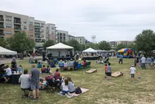
In Mueller, the timing of the chill runs through a busy calendar. The Texas Farmers’ Market at Mueller typically draws Sunday morning crowds to the Browning Hangar. Gusty winds and a quick temperature drop could affect vendor setups and turnout. Outdoor dining along Aldrich Street and at nearby patios—including the H-E-B Mueller plaza—will likely see a sharp transition from shorts to jackets within a day. The Thinkery’s outdoor playscapes and weekend park programming around Mueller Lake Park may shift inside if winds peak during open hours.
Austin ISD campuses that serve Mueller could adjust outdoor activities, including practices and recess, if winds remain elevated or morning wind chills dip. CapMetro routes through Mueller along 51st Street and Berkman Drive can operate in windy conditions, but delays are possible when strong fronts move in and riders may face colder waits at uncovered stops.
New street trees and landscaping—common across the neighborhood’s medians and pocket parks—face a quick sequence of heat followed by a chill. That swing can stress recent plantings if soil dries out ahead of the front. Property managers and homeowners often water lightly before a cold push and secure loose coverings if there is a risk of patchy frost.
Practical steps for residents this week:
- Secure light outdoor items and patio furniture ahead of expected 25–35 mph north winds with higher gusts, as described by the San Antonio Express-News.
- Protect tender plants and recent tree plantings; consider a light watering before the front and use breathable covers if needed, with Austin’s average frost date near Nov. 10 from The Old Farmer’s Almanac.
- Switch thermostats from cooling to heating and replace air filters to handle a quick heating demand after near-record warmth noted by the San Antonio Express-News.
- Check on neighbors who are sensitive to cold, and plan for cooler, windy waits at CapMetro stops.
- Watch for event and game updates from Austin ISD and local venues if winds affect outdoor schedules.
The bigger pattern
The broader setup points to a season that may lean warm and dry in Central Texas. NOAA has declared a return of La Niña, a Pacific pattern that tends to bring Texas warmer, drier fall and winter conditions; San Antonio, as a regional marker, could run about 1.3°F warmer and roughly 28% drier than average, according to the San Antonio Express-News. That outlook does not preclude sharp cold snaps. Short-lived but strong fronts—like the one expected this weekend—can still punch through, sending temperatures down quickly with gusty north winds, as outlined by the San Antonio Express-News.
For Mueller residents, the week captures a familiar Central Texas rhythm: a late warm spell that tempts 90 degrees, a quick frontal passage, then a few brisk mornings before temperatures moderate. With average frost timing near mid-November in Austin, per The Old Farmer’s Almanac, the neighborhood’s shift from sun-soaked afternoons to jacket weather is right on cue—though the wind may make it feel like winter arrived overnight.
Read the press release on www.kvue.com.